Prairie Legacy Wilderness
North Dakota Citizen’s Proposal for Wilderness
on the Dakota Prairie Grasslands
North Dakota Wilderness Coalition
Published February, 2008.
We acknowledge the help of the following people without whom this proposal would not have been possible.
Lillian Crook
Bart Koehler
Kirk Koepsel
Carol Jean Larsen
Larry Nygaard
Mary Sand
Wayde Schafer
Jan Swenson
Webster Swenson
And thank the following photographers for their contributions.
Larry Thuner
Jean Legge
Larry Nygaard
Jan Swenson
This document is dedicated In Memoriam to Kirk Koepsel for his vibrant, unceasing commitment to public wildlands protection in North Dakota, and Webster Swenson for his hands-on expertise and insight in bringing this proposal to life.
If you are reading this North Dakota citizens’ proposal for Wilderness on the Dakota Prairie Grasslands, you are important. Ultimately, the decision will be yours.
The North Dakota Wilderness Coalition is the Wilderness choir. Fear of unremitting loss drives this
Wilderness proposal, as well as love of the landscape that remains. It is no longer wise to politely hum; the choir has to sing to be heard. We are singing.
You are important.
So is Wilderness.
In the early 1970s, five hundred thousand acres on the Dakota Prairie Grasslands’ western-most Little Missouri National Grassland unit qualified for Wilderness designation. By 1977, when the second Roadless Area Review and Evaluation was complete, the number of acres eligible had been cut in half. With the signing in July 2002 of the current Land and Resource Management Plan for the Dakota Prairie Grasslands, less than 40,000 acres are managed by the Forest Service as “Suitable for Wilderness.” Undeveloped wild land is disappearing – fast.
Under the Multiple-Use Sustained Yield Act of 1960 and specifically, the 1976 National Forest Management Act, the Forest Service is directed to “in particular, include coordination of outdoor recreation, range, timber, watershed, wildlife and fish, and wilderness.” Yet, on the Dakota Prairie Grasslands, we have no Wilderness. Without the help and awareness of the citizenry and leadership of North Dakota, these remaining special landscapes will be roaded and developed for commercial use. There is no reason to believe otherwise. The North Dakota Wilderness Coalition seeks to educate the public and our leadership to insure a lasting annuity – Prairie Legacy Wilderness.
Currently, a mere 1/10th of 1 percent of the land area of North Dakota is protected as Wilderness: Chase Lake Wildlife Refuge in Stutsman County, Lostwood Wildlife Refuge in Burke County, and Theodore Roosevelt Wilderness within the North and South Units of Theodore Roosevelt National Park.
In 1903 Theodore Roosevelt stated, “Shortsighted men…in their greed and selfishness will, if permitted, rob our country of half its charm by their reckless extermination of all useful and beautiful wild things.” If the areas in this citizens’ proposal were permanently protected as Wilderness, an additional 1/10th of 1-percent of the land area of North Dakota would also be protected as Wilderness. This is not unreasonable. This is not “greed and selfishness” on the part of Wilderness advocates. It is a common sense proposal for the 21st century, and for the future well being of our nation and our heirs. It is not merely a modest proposal; it is humble.
Prairie.
North Dakotans know prairie – the shouldering wind; the biggest sky anywhere; the grass-topped
butte; a rocky outcrop; uninterrupted dune and swale; a shady draw; the ephemeral spring.
Legacy.
To give and receive; it is the best of all worlds – and so uniquely reflective of humankind. These
landscapes that are an American inheritance become a show of faith and a bequest to those who will follow.
Wilderness.
Why? It is the national construct, the mechanism, our singularly American society has created
to protect our greatest natural assets.
To what end?
So that we as North Dakotan’s can claim the first National Grassland Wilderness, honoring our
past, recognizing the value for present day, and insuring high quality natural experience into the future.
Prairie Legacy Wilderness recommends Wilderness designation of the four “Suitable for Wilderness” management areas on the Little Missouri National Grassland: Twin Buttes, Kendley Plateau, Bullion Butte and Long X Divide; and an additional 5400-acre roadless area on the Sheyenne National Grassland located in southeastern North Dakota and renown as the largest tract of publicly owned northern tallgrass prairie left in the world. The proposal also includes Wilderness Study Area designation for the majority of Lone Butte Inventoried Roadless Area, a highly scenic, wildlife rich, uniquely positioned area adjacent to the North Unit of Theodore Roosevelt National Park and Long X Divide “Suitable for Wilderness”. Sacrificed to pressure from the oil industry in the last Dakota Prairie Grasslands planning process, it warrants better. Previously “not offered” for mineral development, Lone Butte is now extensively leased, but with no surface disturbance allowed: drilling will be horizontal, from outside the area. Wilderness Study Area designation will stave off policy changes that may authorize roads and surface disturbance, and will allow for true Wilderness recommendation when current leases expire.

Mineral development is a major threat to the areas on the Little Missouri National Grassland. An ever-tightening noose threatens the still significant islands of wondrously rich wild land in the Little Missouri National Grassland. Current federal energy policy has resulted in a five-fold increase in annual Applications for Permit to Drill, and increased use of Categorical Exclusions (limiting public involvement) speeds up that process. It is estimated that the Reasonably Foreseeable Development Scenario (an official 10-year forecast) may be reached within an unprecedented four years. A federal study of highest potential onshore oil and gas producing geological basins under public ownership revealed that the Little Missouri National Grassland is authorized for double the national average of surface disturbance and development. A full 95% of the Grassland is available and authorized for leasing.

Prairie Legacy Wilderness encompasses less than 4-percent of the Dakota Prairie Grasslands. Wilderness is not about denial of oil industry growth; it is about reasonable limits that contribute equally important value to the public good. Distinguished author David Orr’s statement comes to mind: "On occasion it requires the good sense and moral energy to say no to things otherwise possible and, for some, profitable." While oil and gas development historically forecasts a boom-and-bust economic scenario, permanently protected public land, Wilderness, offers insightful long-range benefits.
Tourism ranks second in North Dakota’s economic portfolio. Furthermore, long-term community growth and rural health are promoted by diversity within economic strategies, particularly as it relates to access to Wilderness, National Parks and other protected landscapes. The 21st century lifestyle is increasingly attracted to authentic, primitive experiences – for reconnectivity to non-motorized solitude, spiritual renewal, physical awareness and recreation. Saving wild places betters the odds that North Dakota’s small rural communities will remain over the long run, will grow, will hold on to their own while welcoming newcomers.
Wilderness secures oases of wildlife habitat essential to species protection. Mineral development, with its fragmenting network of roads and infrastructure, and the expansion of small-acreage ranchettes intermingled with public lands each force wildlife to seek protected areas. Increased large game populations utilizing the natural diversity of Wilderness offer a primitive hunt experience fast fading in North Dakota and across the West.
North Dakotans have a mixed self-image in the esteem department. We send our children off to the wider world to make something of themselves. We grow old without them. Just as we as a State are rethinking that tendency, watching our population age, and fighting to fill jobs, we must rethink the value of our landscape. Not just that which produces crops and coal, but that which evolved from the beginning.
N. Scott Momaday captures that essence of place in his modern classic, The Way to Rainy Mountain:
Once in his life a man ought to concentrate his mind upon the remembered earth, I believe. He ought to give himself up to a particular landscape in his experience, to look at it from as many angles as he can, to wonder about it, to dwell upon it…He ought to imagine the creatures there and all the faintest motions of the wind. He ought to recollect the glare of noon and all the colors of the dawn and dusk.
It is with that dignity and eloquence that this proposal seeks Wilderness.
Contemporary research in early child development is just beginning to reaffirm the integral human need for nature-based, primary experience. The permanent protection of Wilderness acts as a reservoir, an open classroom, a library and a playground for the directly personal and uniquely regenerative exploration essentially formative to postmodern children living in the information age. In a 21st century world where much is expected of our children, the multi-sensory experience found in nature is simply there, accepts everyone, and enriches all.
Global climate change leads world crisis concerns. Wilderness acts as the canary-in-the-cage, documenting not only the natural world as it has been, but expressing base changes due to global climate shifts. One day, Wilderness may prove the scientific template for world recovery, sustainability and renewal.
You are important to us.
So is Wilderness.
Over the years and decades, Wilderness proponents have argued for permanent protection on many levels, for many concrete reasons. Ultimately, Wilderness comes down to human need.
Some folks simply need to know Wilderness is there, even if they never see it. Others seek to replenish mind, body or soul on a once or twice a year camping trip; while still others see six week intervals as the limit of their capacity for separation. For the most smitten, it is an everyday call.
Perhaps the need for Wilderness reflects childhood experience, a certain mindset, or a recessive gene. To put aside all the excessive finery, the consumerism, the superfluous creature comforts, the technology, the mechanical noise, the hurry and bustle, the electric buzz and glitter, is that not deeply human? Certainly Wilderness is respite and restoration. Decades-long Wilderness ranger Randy Morgenson put it succinctly, in Wilderness “the questions aren’t answered, they dissolve.” (Eric Blehm, The Last Season. HarperCollins, April 2006) For many, this need for primary experience is as real as the need for food.
We are asking that you support Wilderness designation of North Dakota’s Prairie Legacy – that 1/10th of one percent of our State’s land area, that 3.87 percent of the Dakota Prairie Grasslands, that little piece of “what was and still is” that makes us whole. Let it not be your child or mine, your progeny or mine, who asks why we faltered. Let us, instead, be the blessing.
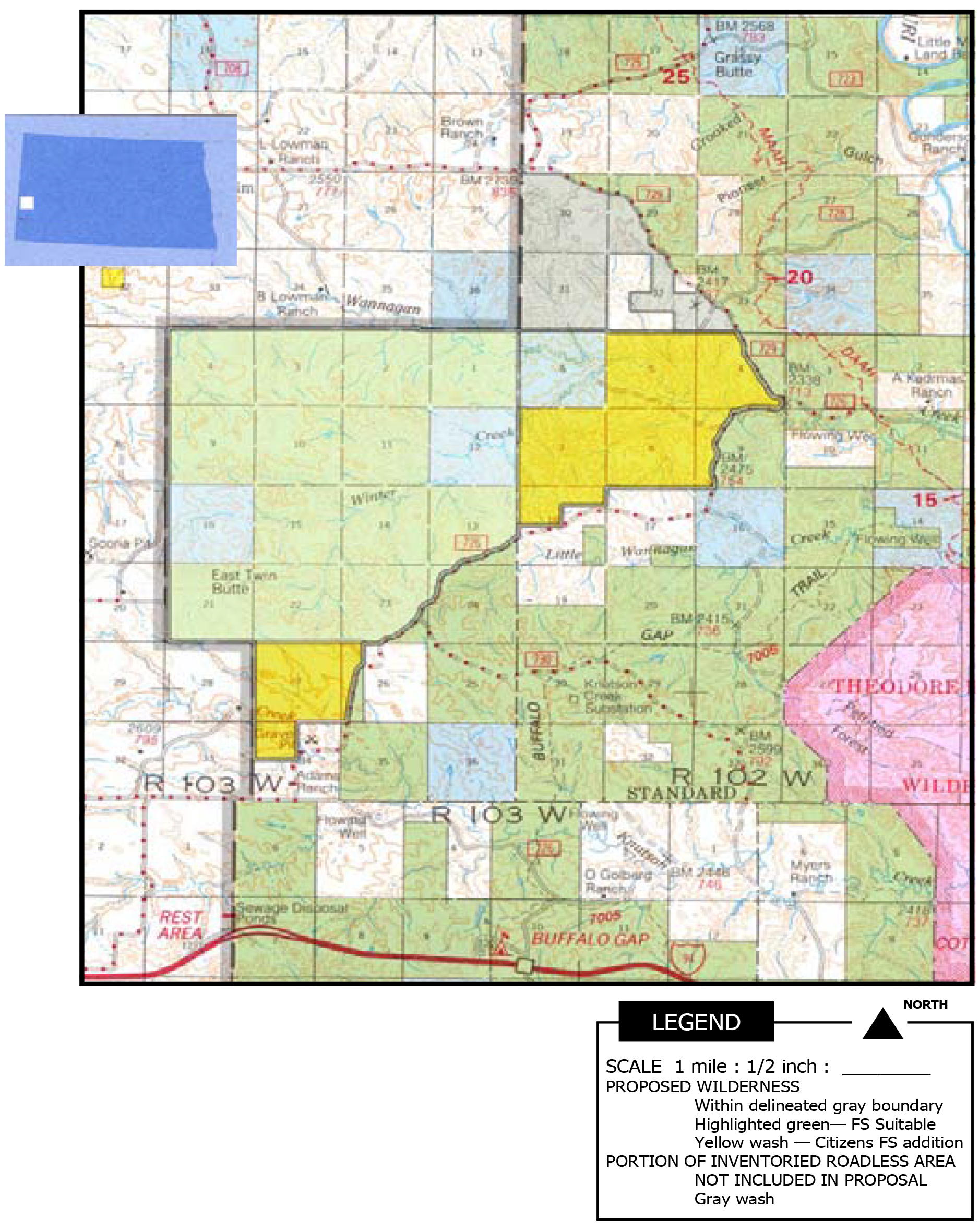
Bullion Butte Proposed Wilderness
T137N_R102W / T137N_R103W
Citizen Proposal for Wilderness: 9,720 acres
+160 FS, 640 State, 40 private
USFS Suitable for Wilderness Acreage: 8,880
USFS Inventoried Roadless Area: 19,780
Bullion Butte Proposed Wilderness is located southeast off FS Route 745, 15 air miles south of the village of Medora, ND OR west off East River Road (FH3) 14 air miles northwest of the village of Amidon, ND.
Bullion Butte: “Island in the Sky”
Bullion Butte is the pivotal landmark in the southern Little Missouri National Grassland. Here the Little Missouri River yielded in geological history to an even broader ancestral Bullion Butte, swinging 12 miles east before resuming its northerly course.
Set off within this Big Bend, Bullion Butte rises dramatically as an island in the sky. At 3358 feet above sea level, it is North Dakota’s sixth highest elevation and offers one of the state’s premier vistas.
Grassy, rock-strewn slopes and thick woody draws rise to talus-skirted, abrupt sandstone cliffs. Several natural springs are found in the area.
Approach from the north, west, or east startles, and then spellbinds, as a large spring-fed inner gorge breaks steeply away to the south. On the edge of a world within a world, golden eagles build aeries in the sheltering cliffs of this horseshoe-shaped summit, itself a treeless grassy plateau alive with songbirds and wildflowers.
Sharp-tailed grouse, mule deer and white-tailed, bighorn sheep and pronghorn find diverse niches of habitat and offer hunters an exhilarating setting. Raptors soar on rising thermals, and rattlesnakes find shelter and prey amongst the fallen blocks of stone.
The unique Ponderosa Pine Area lies dark across the river to the south. Landmark buttes are visible 25 miles distant in all directions, and a view into Kendley Plateau is just across the river to the east.
Additions in Proposal Acreage
640 acres State School Land (SSL) 40 acres private 160 acres FS Little Missouri corridor
Mineral Status
Five non-producing federal leases expired in March 2007; currently, unavailable for lease; no private minerals. SSL not leased.
Grazing
Medora Grazing Association 4 allotments partially or fully within the area 4 permittees Grazing will continue after Wilderness designation.
Recreational Trails
No formally established recreational trails exist within Bullion Butte.
Boundary Management
Bullion Butte is irregular in shape, but is well defined. It is bound by FSR 755 and 760 to the west, by private ownership to the north and south, and by public land along section lines to the east. One SSL section on the west would facilitate boundary management, adding an additional 640 acres. The SSL section and exchange or purchase of a 40-acre private inholding would increase area integrity.
Kendley Plateau Proposed Wilderness
T138N_R101W / T138N_R102W / T137N_R101W / T137N_R102W
Citizen Proposal for Wilderness: 16,810 acres
+4130 FS, 1510 State, 0 private
USFS Suitable for Wilderness Acreage: 11,170
USFS Inventoried Roadless Area: 16,900
Kendley Plateau Proposed Wilderness is located east off East River Road (FH3) 11 air miles south of the village of Medora, ND OR east off East River Road (FH3) 15 air miles northwest of the village of Amidon, ND.
Kendley Plateau: “Heart of the Badlands”
Kendley Plateau truly is the heart of the Badlands. Located at the core of the Little Missouri National Grassland’s southern extent, its juices pump soul into the meaning of Wilderness. Largest among Forest Service management’s Suitable for Wilderness, it is the culmination of Badlands diversity.
This exotic triangle is defined by the valleys of Dantz Creek, its larger twin, Bear, and Toms Wash as they journey east to west toward the lifeblood Little Missouri River. Dantz roughly defines the northern extent of this area, exposing an ancient geology of strata in blues, gray, white, and red.
The namesake Kendley Plateau was etched out millennia ago as flatlands to the east were cut by Dantz and Bear. It is possible to hike to the precipitous western flank of this mammoth landform from a steady course atop the rolling prairie.
Beyond is a tumultuous landscape of remnant strata inhabited by mule deer, bobcat, and coyote—a hunter’s paradise; a hiker’s Zion. Notably, the area is a stronghold for bighorn sheep.
Cliffs and Hanley Plateaus stand watch to the south. Unlike Kendley, Cliffs stands isolate, rearing dramatically from its makers’ fingers, the steady thrumming of Bear Creek and Toms Wash. Less austere, Hanley rolls peaceably to the southeast and prairie beyond.
Summits grant a powerful view stretching leagues in all directions. Canyons, valleys, and draws offer solitude and freshening rest.
Seasonal wildflowers grace prairie, butte, and woody draw. The Rocky Mountain juniper— singly marking the landscape or in deep, moss-floored forests— also is found stunted, twisting from buffeted holds atop giant sandstone caprocks.
Here is the puzzle tossed out on the landscape. Here, the myriad wild and rambunctious pieces fit. It is wild nature at its kaleidoscopic best.
Additions in Proposal Acreage
1510 acres State School Land 4130 acres FS Hanley Plateau
Mineral Status
Eight non-producing leases in Suitable expired in 2007; one producing lease at the northern edge of Suitable is NSO; two non-producing leases in Hanley are NSO. Suitable is otherwise unavailable for lease; Hanley is NSO. No private minerals. State Land is partially leased, but non-producing.
Grazing
Medora Grazing Association 8 allotments partially or fully within the area 9 permittees Grazing will continue after Wilderness designation.
Recreational Trails
The Medora Ranger District is building a southern extension of the Maah Daah Hey Trail, which will cut off @190 acres of Suitable on Kendley’s southern boundary. The Record of Decision for that project mitigates those lost acres by addition to Bullion Suitable or Twin Buttes Suitable acreage within the Medora Ranger District.
Boundary Management
Kendley Plateau consists of two contiguous blocks: FS Suitable and the additional Hanley Plateau. East River Road (FH3) provides much of the western boundary with Forest Routes 765 and 767 on much of the east. Private land to the north, mid-east and southwest are well defined. The nature of landmarks within the area, both by elevation and water course, provide further definition. Two State sections and a portion of a third increase the integrity of natural boundaries.
Long X Divide Proposed Wilderness
T147N_R99W / T147N_R100W
Citizen Proposal for Wilderness: 10,670 acres
-80 FS and +10 FS, 640 State, 0 private
USFS Suitable for Wilderness Acreage: 10,100
USFS Inventoried Roadless Area: 10,100
Long X Divide Proposed Wilderness is located west off HWY #85 15 miles south of Watford City, ND and lies immediately to the south of the North Unit of Theodore Roosevelt National Park.
Long X Divide: “Southern Sister”
As one treks up the broad valley of Summit Creek, south from the CCC Camp at the northern border of Long X Divide, the quiet is exaggerated by ringing in one’s ears.
Slopes up and out of the canyon, and banks along the incised creek bed create benches vegetated with buffaloberry, silver sage, and higher up, Rocky Mountain juniper. Here is expansive solitude. This is wilderness.
Switch-backing upward into higher tree country, one is awestruck by the vast forested green of Summit Canyon to the southeast and the contrasting aridity of Theodore Roosevelt National Park’s North Unit across the Little Missouri River to the north. Southern sister of the North Unit, the view from Long X Divide reveals a near desert aspect; reason enough to be called “Badlands.”
Corral Creek, with its cottonwood, ash, chokecherry, and bermed evidence of flashfloods, meanders into west Long X Divide from the southeast. Cutting through remote canyons and rough terrain, it will journey beneath the southern flank of the Park’s Achenbach Hills and beyond.
Pockets of aspen forest, rare to the Little Missouri River valley, grant one more layer of color, auditory delight, and wildlife habitat.
Expansive mixed-grass prairie uplands in central and northwest Long X provide rich primitive hunting opportunity - with common sightings of mule deer, bighorn, and elk.
Long X Divide is the only Suitable area on the Little Missouri National Grassland that includes the mature cottonwood forest of its namesake – the Little Missouri River.
Additions in Proposal Acreage
10 acres FS immediately to the west of the CCC Camp
640 acres State School Land section Approximately
80 acres of the FS Suitable acreage would be lost due to an existing power line corridor adjacent to HWY 85
Mineral Status
No federal leases, unavailable for lease. No private minerals. State section is leased, non-producing.
Grazing
McKenzie Grazing Association
3 allotments partially or fully within the area
6 permittees
Grazing will continue after Wilderness designation.
Recreational Trails
Long X Divide trails coordinate with those of the North Unit of Theodore Roosevelt National Park.
Within Long X Divide Proposed Wilderness:
6.5 miles of the 96-mile Maah Daah Hey Trail
8.5 mile Long X Loop
3.9 mile Summit
A portion of the MDHT and Long X Loop would be closed to mountain bike and other mechanical use, except for wheel chairs. Going hand-in-hand with this Wilderness designation would be authorization and funding for building and maintaining an agreed-upon alternative route which would bypass the area. Summit Trail is already non-motorized, non-mechanical.
Boundary Management
Long X Divide is rectangular, running 6 miles west to east and 2-3 miles north to south. It is bordered by the Park to the north and west, private land to the south, and HWY 85 to the east. Closure of Forest Route 825 would be confirmed. One State section would be included to facilitate management and area integrity.
Twin Buttes Proposed Wilderness
T141N_R102W / T141N_R103W
Citizen Proposal for Wilderness: 13,590 acres
+3650 FS, 1920 State, 0 private
USFS Suitable for Wilderness Acreage: 8,020
USFS Inventoried Roadless Area: 13,380
Twin Buttes Proposed Wilderness is located 5 miles west of the South Unit of Theodore Roosevelt Park and may be accessed off I-94 2 miles west of Medora, north 8 air miles on FS 730.
Twin Buttes: “Pronghorn Horizons”
Intermittent sandstone caps in Twin Buttes create a haunting landscape, exposing dramatic hues of geologic deposition. Barren faces throughout the badlands portion are captivating for the splendid color and harshness they offer. The flat-topped buttes and fallen columns of rock evoke feelings of walking through ancient ruins. Petrified logs are common in the area; in one instance stream erosion has created a petrified log bridge.
On southern slopes the flora consists primarily of native grasses, along with yucca, sage, and cactus. Draws and north slopes are sparsely wooded with ash, juniper, cottonwood, willow, wild plum, and chokecherry. Much of the western portion is open rolling grassland.
The area’s diverse terrain shelters pronghorn, mule deer, horned toads, prairie rattlesnake, coyote, jack rabbit, and prairie dogs. Hunters find the region well populated with game species and its landscape conducive to backcountry hunts reminiscent of bygone days.
Dendritic fingers of Winter Creek fall off the eastern flanks of East Twin Butte, working northeasterly toward Wannagan Creek and the Little Missouri River. East Twin Butte offers a panoramic view of regional landmarks.
Twin Buttes holds a special status as the only area in North Dakota ever recommended by the Forest Service for Wilderness designation.
Additions in Proposal Acreage
1,920 acres State School Land
3,650 federal in two blocks
Mineral Status
No federal leases in Suitable; unavailable for lease.
No federal leases in southern addition; is NSO.
Eastern FS addition is leased, non-producing, NSO under reinstatement of Roadless Area Conservation Rule.
No private minerals.
State land is leased, but non-producing.
Grazing
Medora Grazing Association
6 allotments partially or fully within the area
7 permittees
Grazing will continue after Wilderness designation.
Recreational Trails
No formally established recreational trails exist within Twin Buttes.
Boundary Management
Twin Buttes is bordered to the north and west by the Little Missouri National Grassland boundary and by private ownership. Forest Route #726 defines nearly all of a southwest to northeast
transect that serves as the third boundary for this roughly triangular acreage.
Three sections of State are included to facilitate boundary management and area integrity.
Sheyenne Proposed Wilderness
T135N_R52W / T135N_R53W
Citizen Proposal for Wilderness: 5,410 acres
USFS Inventoried Roadless Area: 14,540
Sheyenne Proposed Wilderness is located 23 miles east and 3 miles north of Lisbon, ND north off State HWY 27. It is 6.5 miles northeast of the village of McLeod, ND.
An hour’s drive from the region’s largest metropolitan area of Fargo/ Moorhead lies an iconic landscape, writ large as the Eden of childhood imagination. An intermingling of grassy meadow-and-swale and bur oak woodlands, Sheyenne National Grassland is a remnant of time eternal.
The 5,410-acre proposed Wilderness area is located in the northeast quadrant of the 14,540-acre Sheyenne Inventoried Roadless Area. It is home to two unique critically endangered ecosystems in this nation, and indeed, across the continent: tallgrass prairie and bur oak savanna.
The Sheyenne is built on the ancient Sheyenne River Delta formed in the last great Wisconsin glaciation 10,000 to 25,000 years ago. Once draining into ancestral Lake Agassiz, which covered much of eastern ND, western Minnesota, and north into Manitoba (Lake Winnipeg is a remnant), the Sheyenne deposited silt and sand visible today as choppy and hummocky dunes, dressed out in wondrous grass. The local water table remains high, often within 10 feet of the surface. Frequently, unexpected seeps and wetlands appear.
Rare oak savanna, which has declined by more than 98% over its historic occurrence, is interspersed with thickets of chokecherry, smooth sumac and wild plum, and stands of quaking aspen. Such diverse vegetation and rich under story create habitat for an abundance of wildlife.
The area is an oasis within an agricultural landscape; home to birds such as black-billed cuckoo, scarlet tanager, rose-breasted grosbeak, various prairie sparrows, and great crested flycatchers. Notably, the Sheyenne National Grassland harbors one of two remaining populations in North Dakota of the impressive greater prairie chicken.
Tallgrass prairie, familiar to original peoples and awe-inspiring to early homesteaders, can stand chest high, a true inland sea of grass. Big bluestem, sand bluestem, Indiangrass, switchgrass, and related wildflowers, including unusual lady slippers, vetches, lady tresses, and the remarkable and threatened western prairie fringed orchid, provide a wealth of varied and distinct plant life.
Butterflies – Dacotah Skipper, Great Spangled Fritillary, and numerous others – thrive on the essential host materials produced in these rich and varied microhabitats.
Mineral Status
No leases. No private minerals.
Grazing
Sheyenne Valley Grazing Association 5 allotments 12 permits / permittee number varies Grazing will continue after Wilderness designation.
Recreational Trails
The North Country National Scenic Trail wanders @5 miles through the proposed area. Current use is almost exclusively foot and horseback. This small section of the Trail would be closed to mountain bike and other mechanical use, except for wheel chairs. Going hand-in-hand with this Wilderness designation would be authorization and funding for building or providing and maintaining an agreed-upon alternative route which would bypass the area.
Boundary Management
The proposed area is roughly triangular in shape. It is bound on the east by County Road 23 and private land, on the south by Grassland Route 1212A, and on the stepped SW to NE third side by Grassland Routes 12125A, 1237, 12126, boundary with a 160 acre parcel of private land, the terminus of 1237A, and again along the Grassland boundary.
Frequently Asked Questions about Wilderness
What is Wilderness?
Wilderness is many things to many people and to many cultures. In world religions wilderness can vary from the landscape of redemption to the landscape of damnation, temptation, and back again. To European immigrants in the New World, wilderness meant an entire continent; quite contrary to the inhabiting indigenous peoples’ established nations and socio-political organization developed over millennia.
To the young Theodore Roosevelt of 1883, wilderness was the grand American frontier that promised challenge and adventure: man-making experience at the heart of Western thought that would imminently succumb to transforming 20th century civilization. A year later, in 1884, that same wilderness was to be a widowed Roosevelt’s solace and healing from unbearable grief.
In this citizens’ proposal for Prairie Legacy Wilderness, the term Wilderness is succinct. It is Wilderness as defined by the congressional Wilderness Act of 1964, signed into law by then President Lyndon B. Johnson and establishing permanent protection for “land retaining its primeval character and influence, without permanent improvements or human habitation, …which generally appears to have been affected primarily by the forces of nature, with the imprint of man’s work substantially unnoticed…”
Upon signing of the Act on September 3, 1964, President Johnson said, “If future generations are to remember us with gratitude rather than contempt, we must leave them something more than the miracles of our technology. We must leave them a glimpse of the world as it was in the beginning, not just after we got through with it.”
This Wilderness can only be designated by an act of the US Congress and can be established only on federally owned lands. Wilderness is typically managed by the US Forest Service, the Bureau of Land Management, the National Park Service, or the US Fish and Wildlife Service; and management remains with its parent agency. In this proposal, Wilderness would continue to be managed by the US Forest Service.
Is there currently official Wilderness in North Dakota?
Yes.
North Dakota has a land area of 45,225,699 acres. Currently 1/10th of 1 percent (.088 percent) of that land is officially protected as Wilderness:
- 19,410 acres within the North Unit of Theodore Roosevelt National Park
- 10,519 acres within the South Unit of Theodore Roosevelt National Park
- total of 29,920 acres managed by the National Park Service
- 4,155 acres at Chase Lake Wildlife Refuge in Stutsman County
- 5,577 acres at Lostwood Wildlife Refuge in Burke County
- total of 9,732 acres managed by the US Fish & Wildlife Service
- for a grand total of 39,652 acres.
Prairie Legacy Wilderness would protect an additional 1/10th of 1 percent (.124 percent), doubling acreage to 2/10ths of 1 percent.
What is the Dakota Prairie Grasslands?
The Dakota Prairie Grasslands is public land managed by the US Forest Service and contains the areas in this Wilderness proposal. It consists of 1.2 million acres in four grasslands:
- Little Missouri National Grassland in western ND, commonly known as the Badlands.
- Sheyenne National Grassland in southeastern ND – 70,000 acres of tallgrass prairie
- Grand River National Grassland in northwestern SD – 154,000 acres of rolling prairie
- Cedar River National Grassland in south central ND – 6,800 acres of rolling prairie
How were the specific areas on the Dakota Prairie Grasslands included in the Prairie Legacy Wilderness proposal determined?
The Dakota Prairie Grasslands Land and Resource Management Plan, signed into effect in July 2002, designates the four distinct areas of Twin Buttes, Bullion Butte, Kendley Plateau, and Long X Divide in the Little Missouri National Grassland as “suitable for wilderness.” It is now the responsibility of the state and nation’s citizenry to move this recognition forward to Wilderness recommendation and Congressional enactment.
The boundaries of these four areas were slightly enlarged to accommodate supplemental qualifying acreage and to include State lands that would increase management integrity. Fifty-four hundred (5410) acres in the Sheyenne National Grassland are included for Wilderness designation due to the unique and threatened status of their oak savanna/tallgrass prairie.
In addition, Lone Butte in the Little Missouri National Grassland is proposed as a Wilderness Study Area, protecting its surface from developmental disturbance and requesting further future consideration for Wilderness. Lone Butte contains no private minerals and merits permanent protection.
If the Forest Service is already managing these areas as “suitable for wilderness”, why is official Congressional Wilderness designation necessary?
Two reasons:
“Suitable for wilderness” is an administrative/management decision. It is a temporary protection with no permanence, is open to withdrawal, and is subject to national administration changes and political climate.
Secondly, fewer and fewer acres in the Grasslands are being protected from development. In the 1970’s, half of the Little Missouri National Grassland (500,000 acres) qualified for Wilderness designation. Today, less than 40,000 acres in four non-contiguous parcels are managed as “suitable for wilderness”. Only Wilderness designation will stop continual loss.
What human activities or pursuits are allowed in Wilderness?
Livestock grazing, hunting, non-commercial rock collecting, permitted guide services, hiking, camping, horseback riding, canoeing and kayaking, scientific study, mineral claims established prior to designation, bird watching, cross-country skiing, and snow shoeing are all permitted in Wilderness.
How are motorized and mechanized travel restricted in Wilderness?
The Wilderness Act prohibits use of motorized/mechanical equipment and general access by motor vehicles and mechanical transport such as mountain bikes. However, the law makes exceptions for situations such as search and rescue operations, fire fighting to protect adjacent private lands, and insect and disease control. Grazing permittees are allowed to use motorized vehicles to rescue livestock; and the occasional use of motorized equipment, as necessary, is allowed to fix fences and maintain springs and livestock dams.
Would hunting access be diminished?
No. All acres would be open to hunters. Restrictions on motorized travel would present a primitive hunting experience allowing both foot and horseback. Absence of motorized travel in existing management areas has shown increased game populations, assuring a heightened hunting experience.
There are currently over 3,000 miles of roads in the Little Missouri National Grassland. The acreage included in this Prairie Legacy Wilderness Proposal leaves the vast majority of the Dakota Prairie Grasslands open to vehicular travel, while protecting the hunters eager for a more primitive experience.
Would the risk of uncontrolled fire, disease, or insects be greater in Wilderness?
No. The Wilderness Act allows for flexibility to deal with catastrophic wildfires should they occur. Section 4(d)(1) of the Act states that “such measure may be taken as necessary in the control of fires, insects and diseases” within Wilderness. House Report language for the Endangered American Wilderness Act further clarifies that actions to address fire, insect outbreaks, and disease in Wilderness areas include, “the use of motorized equipment, the building of fire roads, fire towers, fire breaks, or fire pre-suppression facilities where necessary and other techniques for fire control. In short, anything necessary for the protection of public health and safety is clearly permissible.”
Furthermore, prohibition of motorized travel and equipment would decrease the likelihood of human started fires.
Would Wilderness interfere with our ability to stop the spread of invasive species?
While the Wilderness Act does not specifically address the issue, the US Forest Service Manual permits measures to control noxious weeds and non-native plants when they threaten lands outside Wilderness or when they are spreading within the Wilderness, provided it is possible to effect control without causing serious adverse impacts in Wilderness values. The minimum tool needed to complete the job is Wilderness management rule of thumb.
Again, prohibition of motorized travel by the general public within Wilderness would decrease incidental transport of plant materials
How does Wilderness impact individuals with disabilities?
Individuals with disabilities may use wheelchairs in Wilderness. The Americans With Disabilities Act of 1990 reaffirmed that nothing in the Wilderness Act should be construed as prohibiting the use of a wheelchair in Wilderness.
How is commercial livestock grazing impacted by Wilderness?
Commercial livestock grazing, where established prior to Wilderness designation, shall be permitted in Wilderness. Maintenance of fences, livestock dams and springs is allowed, along with the occasional use of motorized equipment when necessary, in accordance with the 1980 Congressional Grazing Guidelines.
Prohibition of new mineral development in Wilderness will protect rangeland from surface disturbance, i.e. roads, well pads, truck traffic, water contamination and air quality.
Congressional Grazing Guidelines
From House Report 96-617 of the 96th Congress, 1980
1. There shall be no curtailments of grazing in wilderness areas simply because an area is, or has been designated as wilderness, nor should wilderness designations be used as an excuse by administrators to slowly "phase out" grazing. Any adjustments in the numbers of livestock permitted to graze in wilderness areas should be made as a result of revisions in the normal grazing and land management planning and policy setting process, giving consideration to legal mandates, range condition, and the protection of the range resource from deterioration.
It is anticipated that the numbers of livestock permitted to graze in wilderness would remain at the approximate levels existing at the time an area enters the wilderness system. If land management plans reveal conclusively that increased livestock numbers or animal unit months (AUMs) could be made available with no adverse impact on wilderness values such as plant communities, primitive recreation, and wildlife populations or habitat, some increases in AUMs may be permissible. This is not to imply, however, that wilderness lends itself to AUM or livestock increases and construction of substantial new facilities that might be appropriate for intensive grazing management in non-wilderness areas.
2. The maintenance of supporting facilities, existing in the area prior to its classification as wilderness (including fences, line cabins, water wells and lines, stock tanks, etc.), is permissible in wilderness. Where practical alternatives do not exist, maintenance or other activities may be accomplished through the occasional use of motorized equipment. This may include, for example, the use of backhoes to maintain stock ponds, pickup trucks for major fence repairs, or specialized equipment to repair stock watering facilities. Such occasional use of motorized equipment should be expressly authorized in the grazing permits for the area involved. The use of motorized equipment should be based on a rule of practical necessity and reasonableness. For example, motorized equipment need not be allowed for the placement of small quantities of salt or other activities where such activities can reasonably and practically be accomplished on horseback or foot. On the other hand, it may be appropriate to permit the occasional use of motorized equipment to haul large quantities of salt to distribution points. Moreover, under the rule of reasonableness, occasional use of motorized equipment should be permitted where practical alternatives are not available and such use would not have a significant adverse impact on the natural environment. Such motorized equipment uses will normally only be permitted to those portions of a wilderness area where they had occurred prior to the area's designation as wilderness or are established by prior agreement.
3. The placement or reconstruction of deteriorated facilities or improvements should not be required to be accomplished using "natural materials", unless the material and labor costs of using natural materials are such that their use would not impose unreasonable additional costs on grazing permittees.
4. The construction of new improvements or replacement of deteriorated facilities wilderness is permissible if in accordance with those guidelines and management plans governing the area involved. However, the construction of new improvements should be primarily for the purpose of resource protection and the more effective management of these resources rather than to accommodate increased numbers of livestock.
5. The use of motorized equipment for emergency purposes such as rescuing sick animals or the placement of feed in emergency situations is also permissible. This privilege is to be exercised only in true emergencies, and should not be abused by permittees.